Remote Sensing Workshop on Land-Atmosphere Interactions
Enhance your skills in land-atmosphere interactions with hands-on training and expert guidance.
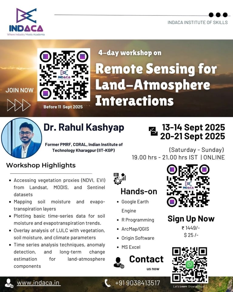
Dates: Sept 13-14 and Sept 20-21, 2025
Time: 7:00 PM - 9:00 PM (IST) | Saturday and Sunday
Mode: Online (via Zoom)
Instructor: Dr. Rahul Kashyap, Former Prime Minister’s Research Fellow (PMRF), at Centre for Ocean, River, Atmosphere and Land Sciences (CORAL), Indian Institute of Technology Kharagpur (IIT-KGP), India.
Workshop on Remote Sensing for Land-Atmosphere Interactions
Master the remote sensing to explore, visualize, and analyze vegetation, soil moisture, evapotranspiration, land use/land cover, and climate drivers
Course Highlights
Practical skills in Google Earth Engine (GEE), ArcMap/QGIS, R, MS Excel, and Origin for environmental data analysis.
Hands-on experience with vegetation, soil moisture, evapotranspiration, and land use datasets from real-world satellites.
Techniques for time series analysis, anomaly detection, and long-term environmental change monitoring.
Confidence to apply remote sensing and GIS tools in academic research, professional projects, and policy studies.
Ready-to-use scripts, workflows, and map outputs for your own environmental or climate studies.


Who Should Enroll
Researchers & Academics: In environmental science, geography, agriculture, hydrology, and climate studies.
Students & Scholars: Pursuing projects in remote sensing, GIS, or environmental monitoring.
Professionals: Working in urban planning, water resources, forestry, and environmental consulting.
Beginners: Anyone curious about using satellite data for land and climate analysis.


Course Highlights
Foundations & Vegetation Analysis: Basics of land-atmosphere interactions, remote sensing concepts, and vegetation mapping using GEE, R, and ArcMap/QGIS.
Soil Moisture & Evapotranspiration: Data exploration, mapping, and time-series plotting with GEE, ArcMap/QGIS, and MS Excel.
Land Use & Climate Interactions: LULC mapping, overlay analysis, and correlation studies using ArcMap/QGIS and R/MS Excel.
Time Series & Change Detection: Visualization, anomaly detection, and long-term trend analysis with GEE, Origin, R, and ArcMap/QGIS.


Frequently Asked Questions
What is the workshop about?
The workshop focuses on remote sensing for land-atmosphere interactions, covering various analytical tools.
What tools will be covered?
What is the course duration?
Is this workshop beginner-friendly?
Yes, the workshop is designed for beginners to intermediate participants.
Participants will gain hands-on experience with Google Earth Engine, ArcMap/QGIS, R, MS Excel, and Origin.
The course runs on September 13–14 and 20–21, 2025, from 7–9 PM IST.
Tools covered include Google Earth Engine, ArcMap/QGIS, R, MS Excel, and Origin.

Contact Us
Get in touch for workshop inquiries and registration.
Remote Sensing Workshop Registration
Secure your spot now to gain practical expertise in analyzing land-atmosphere interactions using cutting-edge geospatial technologies. Limited seats available for an immersive learning experience!
Registration Closes: Sept 11, 2025
Contacts
contact@indaca.in
Socials
Subscribe to our newsletter
Copyright © 2025 Indaca Institute of Skills, All rights are reserved
WhatsApp: (+91) 9038413517
Call: (+91) 7439308037
